Plan from an existing Path Plan (Seasonal Planning)
Seasonal Planing (Plan From a Saved Path Plan)
This feature is to allow users to create relationships between plans, carry forward planned decisions, and make adjustments.
Using the Plan From interface users will select an existing path plan, and are able to make adjustments to;
operation type
equipment type
equipment width (swath width)
headland count
inter-row adjustments
Heading rotation
Wheel Traffic Area
Plan From is Track Alignment to Reference Plan
When creating a plan from a plan, the selected plan on the plans page is called the Reference Plan. This reference plan is important as it determines the starting point for all adjustments enabled by the plan from interface.
In its default state Plan From starts from a inner track aligned state. All adjustments deviate away from the original plan.
 Our "Plan From" feature Alignment Logic: Calculate track geometries and overlay, compare overlap to determine direction of shift for the new Plan, then propagate inner tracks
Our "Plan From" feature Alignment Logic: Calculate track geometries and overlay, compare overlap to determine direction of shift for the new Plan, then propagate inner tracks
Inter-Row Adjustment
Shift a track away from a track aligned state. Inter-row seeding, stubble or debris management practices, and no till practices, are the most prominent.
Inter-row adjustment allows the user to specify the positive or negative shift distance,
Track Rotation
A user can start with a reference plan with a given heading, then save a new plan with a different piece of equipment at a different heading.
Reduce Wheel Traffic Area
Align wheel tracks to the reference plan and minimize wheel traffic area
Path Plan Preview
The Path Plan preview has been reworked with updated styling and now takes advantage of the full height of the page. This change has been made to make room for the updated statistics and metrics that are displayed on the path plan preview.
Expanded metrics included with this release are wheel traffic are. This is show as a total area, as well as a percentage of planned area.
Create a Plan From Plan
To create a Path Plan from a reference Plan:
- From the Plans page select the Path Plan that you would like to generate a plan for.
- Click on Plan From
This allows you to create a new Path Plan that is referencing the guidance lines from the selected Plan - Enter the name for the new Plan
- Select the operation type to create the new plan for
- Select the Equipment to be used on the new plan
A new piece of equipment can also be added by clicking "+Add Equipment" - Verify correct swath width
- Select number of Headland Passes and Interior Passes
- Toggle the option to be enabled
- Use Passable
- Use Tramlines
- Extend Tracks
- Choose Adjustment for the plan
- Complete adjustment settings
- Click Save Plan
Creating Tramlines
In row crop farming, increased planting densities require narrower rows, making it harder for sprayers to avoid crop damage. To solve this, growers can use existing planter technology to create tramlines—unplanted paths for sprayers—by planning seeding based on future spraying routes. This approach reduces crop trampling, saves on seed and fertilizer, and optimizes crop protection coverage, particularly beneficial in no-till systems. Equipment like Precision Planting vDrive and John Deere Exact Emerge can implement this method, potentially saving 3-5% on inputs.

Requirements:
Must have an Application Path Plan created to use as a locator for the Tramline Zones.
The Application Equipment must have Track Width and Tire Width entered for the Application Path Plan. This will be used to generate the Tramline zones in the seeding Path Plan.
To create a Seeding Path Plan with Tramlines Created for Application Operations:
- From the Plans page select the Path Plan that you would like to generate the Tramlines for.
- Click on Plan From
This allows you to create a new Path Plan that is referencing the guidance lines from the selected Plan - Enter the name for the new Plan
- Select the operation type to create the new plan for
- Select the Equipment to be used on the new plan
A new piece of equipment can also be added by clicking "+Add Equipment" - Verify correct swath width
- Select number of Headland Passes and Interior Passes
- Toggle the option to "Use Tramlines"
This enables the system to create Tramline Zone paths for the application equipment to travel, reducing destruction of crop - Select the adjustment option of Track Rotation
Most section/row control systems will perform better at a slight angle (<30 Degrees) to the zone being created to allow for the rows to shut off and come back on accurately. - Enter the desired heading to rotate the tracks from the original Path Plan
- Click Save Plan
Examples of Plans with Tramline Zones
Once saved the new Plan will have a new boundary created that has passable zones created as Tramlines to enable the seeder to shut off sections/rows to reduce damage to the crop
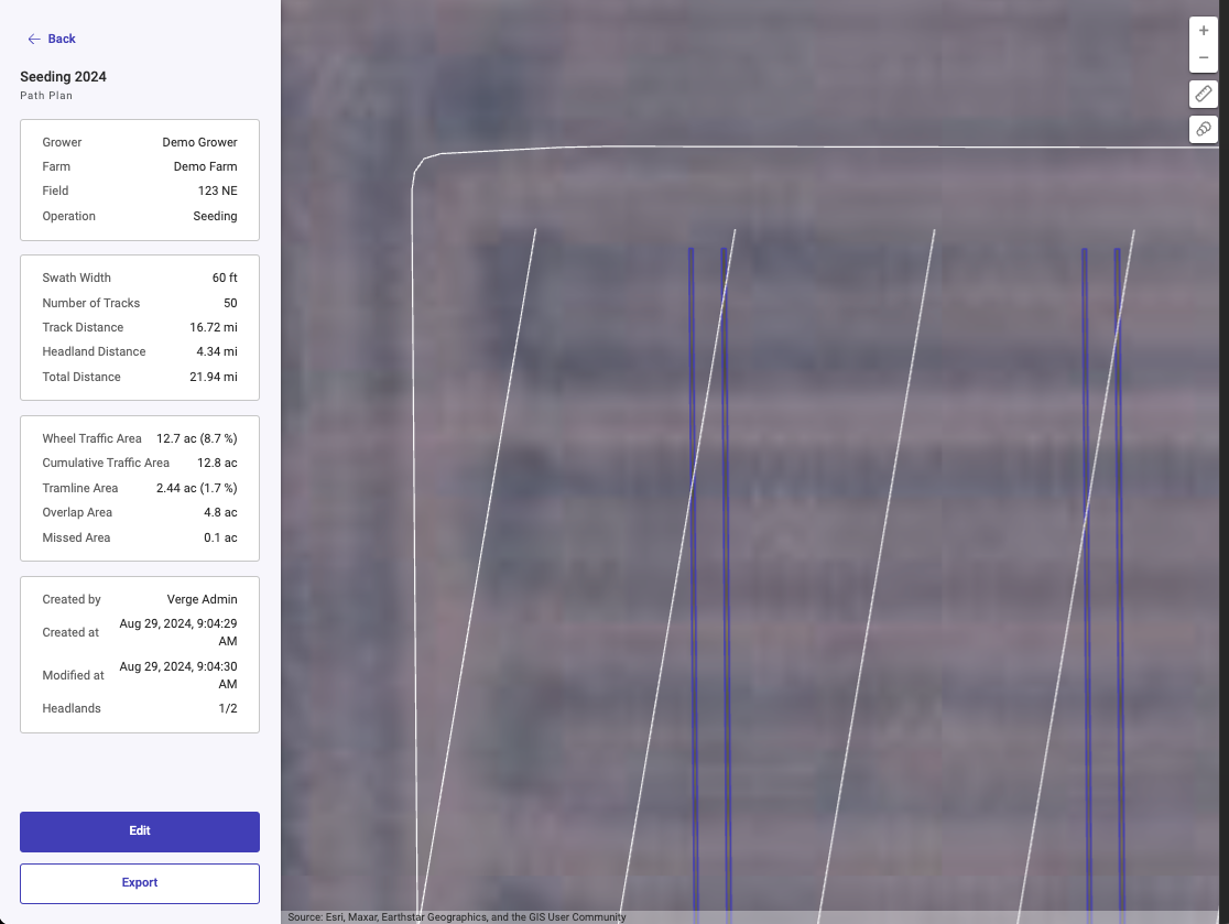
Side by Side comparison of original Path Plan and new Path Plan with the Tramline Zones for the application operations.
Side by Side comparison of original Path Plan and new Path Plan with the Tramline Zones for the application operations.
Related Articles
Creating a Path Plan with Tramlines
Creating Tramlines In row crop farming, increased planting densities require narrower rows, making it harder for sprayers to avoid crop damage. To solve this, growers can use existing planter technology to create tramlines—unplanted paths for ...Path Plan Routing
Problem in the Market today In the market today, where equipment in the field may have a path plan to execute, but an operator is still required to make in-field decisions on how to execute the path plan. Operators must decide where to start, how ...How to create a Path Plan on a Single Field
How to create a Path Plan on a Single Field Please follow the steps below to create a Path Plan on a Single Field. This can be accomplished on either the Home or Land Page. Generate Path Plan from the Home Page Click on the “Start Planning” button ...Planning Credits
Introduction Every user on Launch Pad may purchase planning credits. Each time the "Create Path Plan" button is clicked, a credit is automatically deducted. In other words, each credit corresponds to the creation of a path plan on Launch Pad. This ...How to Create a Path Plan with Curved Tracks
Introduction Path Plans for seeding lines in curves are essential for farming in hilly terrain or areas susceptible to erosion. They are developed with the goal of maximizing productivity, reducing environmental impact, and improving operational ...